Caspian Sea
World's largest inland body of water, an endorheic basin.
The Caspian Sea is the planet’s largest inland body of water, often called the world’s biggest lake but commonly treated as a full sea. It sits in an endorheic basin—meaning it has no outlet to the ocean—straddling Europe and Asia. To its northeast lies Kazakhstan, to the northwest Russia, to the southwest Azerbaijan, to the south Iran, and to the southeast Turkmenistan. Its surface area, not counting the extremely salty Garabogazköl lagoon to the east, is 371,000 square kilometers (about the size of Japan), and it holds 78,200 cubic kilometers of water. The Caspian is famous for its caviar and oil industries, but pollution from oil operations and dams on its inflowing rivers has damaged its ecosystem.
The name comes from the Caspi, an ancient Iranic people who lived southwest of the sea in Transcaucasia. The Greek geographer Strabo noted that the Caspian tribe gave its name to both a region called Caspiane and the sea itself, though the tribe had vanished by his time. The Iranian city of Qazvin shares the same root. In medieval Arabic, the sea was called Baḥr al-Khazar (“sea of the Khazars”), but modern Arabic uses Baḥr Qazvin. Turkic groups often call it the Khazar Sea (e.g., Hazar Denizi in Turkish), referencing the Khazar Khaganate that once ruled north of the sea. In Iran, it is known as the Mazandaran Sea, after the historic province on its southern shore. Old Russian sources called it the Khvalyn or Khvalis Sea, after Khwarezmia. In classical antiquity, Greeks and Persians knew it as the Hyrcanian Sea. Renaissance European maps labeled it the Abbacuch Sea, Mar de Bachu, or Mar de Sala. It was also sometimes called the Kumyk Sea or Tarki Sea.
The Caspian’s South Caspian Basin, like the Black Sea, is a remnant of the ancient Paratethys Sea, so its seafloor is oceanic basalt, not continental granite. It formed about 30 million years ago and became landlocked roughly 5.5 million years ago in the Late Miocene, due to tectonic uplift and falling sea levels. During the Pliocene it was a small endorheic lake, but its area quintupled around the Pliocene-Pleistocene transition. In warm, dry periods it nearly dried up, leaving evaporite deposits like halite, which wind-blown sediments later covered; when cool, wet climates returned, the basin refilled. Today, freshwater inflow from the north makes the northern Caspian almost fresh, while the water grows saltier toward the south, especially along the Iranian shore, where little runoff enters. Average salinity is about one-third that of the ocean. The Garabogazköl lagoon, which dried up after its connection to the main sea was blocked in the 1980s (later restored), can reach ten times oceanic salinity.
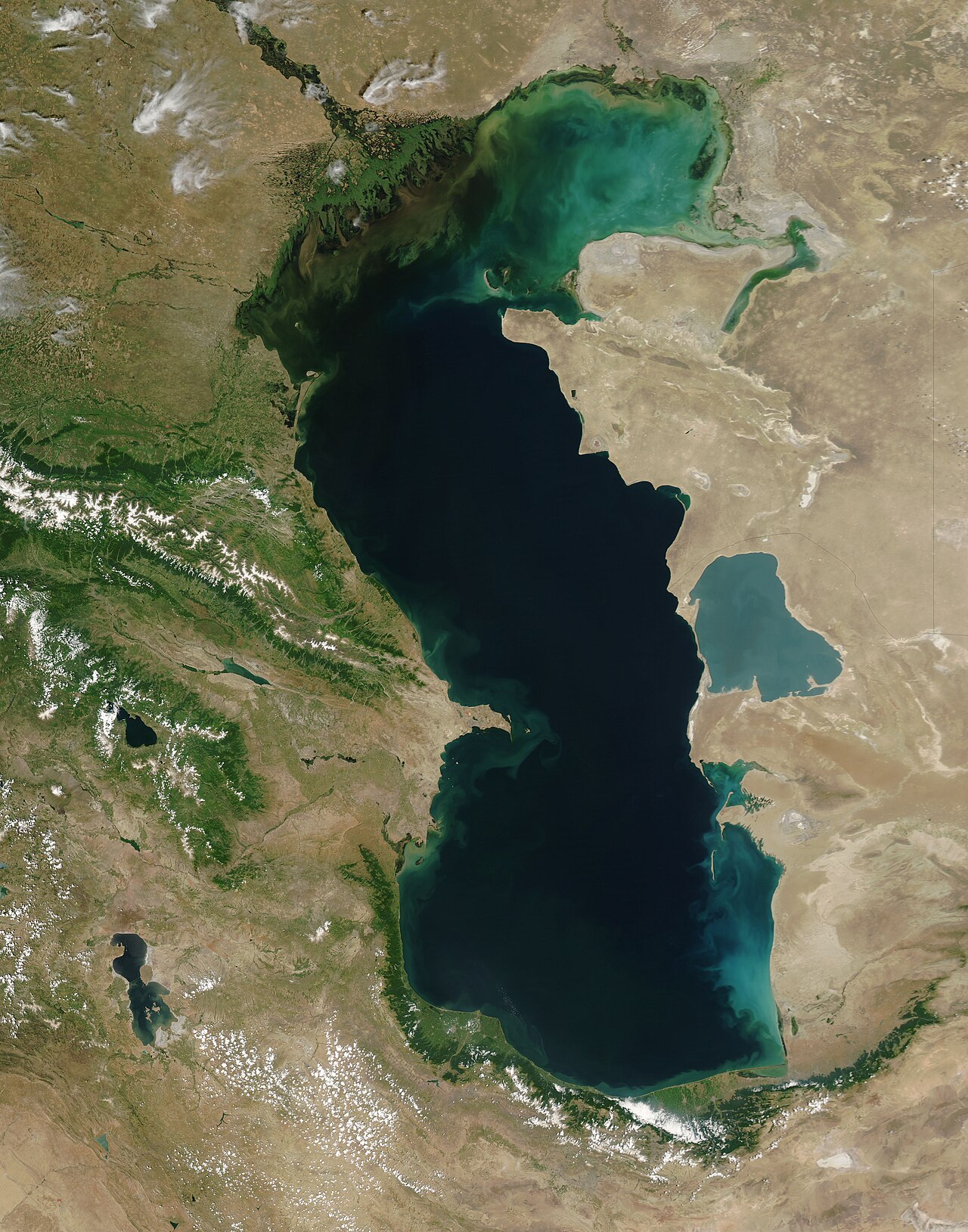
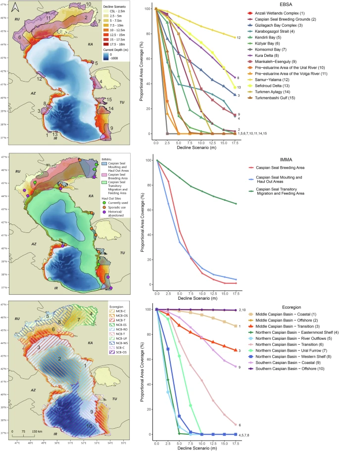
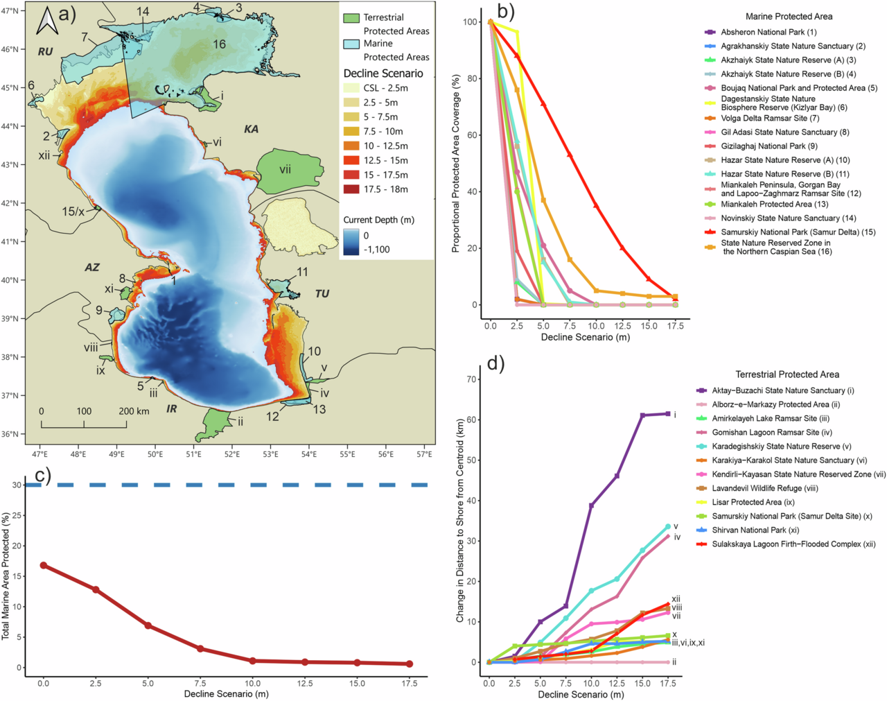
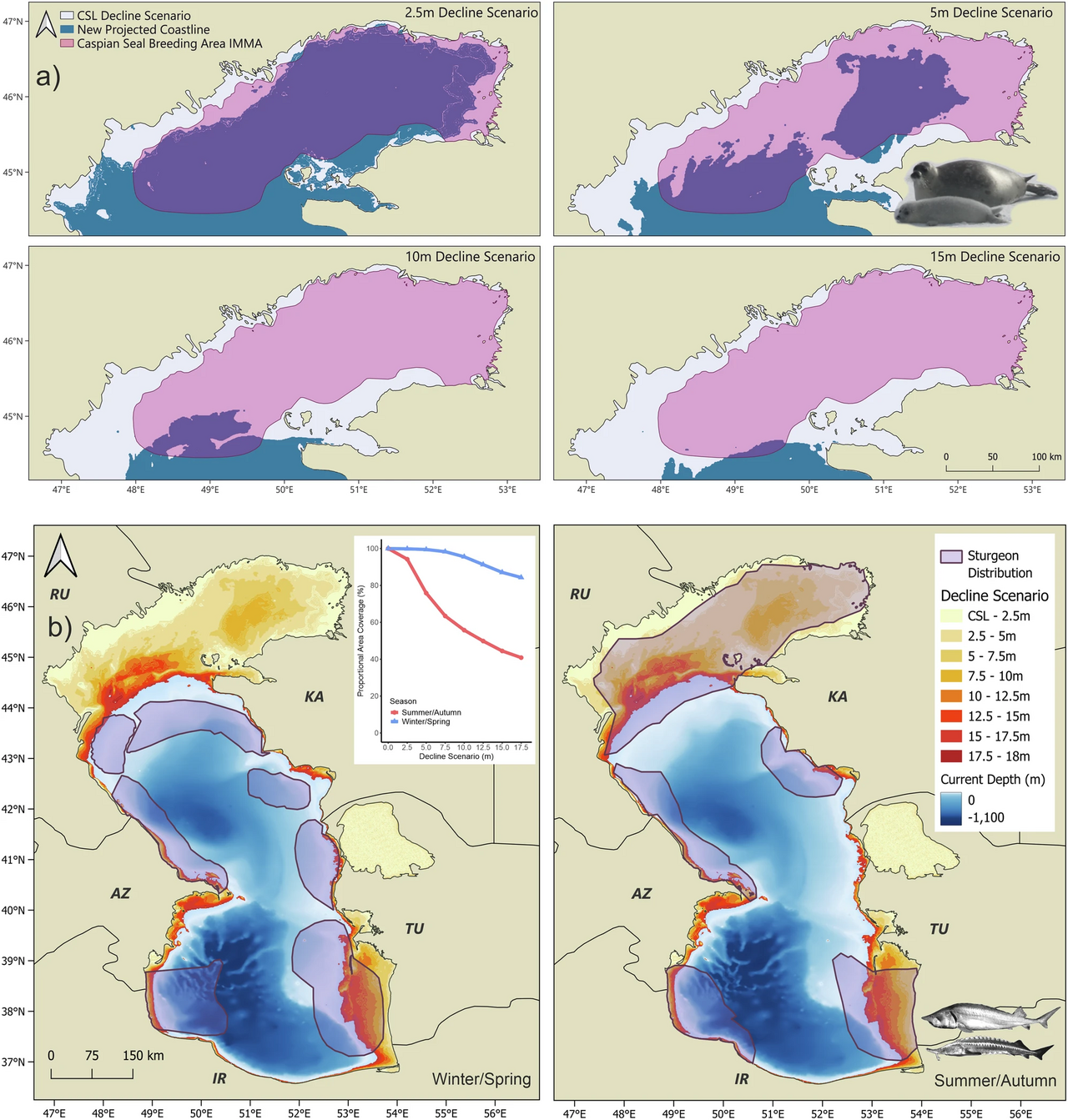
Stretching 1,200 kilometers north to south and averaging 320 kilometers wide, the Caspian covers about 386,400 square kilometers. Its surface lies roughly 27 meters below sea level. The main freshwater source is Europe’s longest river, the Volga, which enters the shallow northern end. Two deep basins form the central and southern zones, creating horizontal differences in temperature, salinity, and ecology. The southern seabed plunges to 1,023 meters below sea level, making it the third-lowest natural non-oceanic depression on Earth, after Lake Baikal and Lake Tanganyika. The Caspian is five times larger than Lake Superior and hosts a wide variety of animal species. However, pollution from the oil industry and dams on tributary rivers has harmed its ecology. Scientists predict that during the 21st century, global warming and desertification will lower the sea’s depth by 9 to 18 meters, potentially causing an ecocide.
- Maximum depth
- 1,023 m (3,356 ft) below sea level
Lore & Background
The sea's name stems from Caspi, the ancient people who lived to the southwest of the sea in Transcaucasia. Strabo (died circa AD 24) wrote that 'to the country of the Albanians (Caucasian Albania, not to be confused with the country of Albania) belongs also the territory called Caspiane, which was named after the Caspian tribe, as was also the sea; but the tribe has now disappeared.' The Iranian city of Qazvin shares the root of its name with this common name for the sea. In Iran, the lake is called the Mazandaran Sea (Persian: دریای مازندران), after the historic Mazandaran Province at its southern shores. Old Russian sources use the Khvalyn or Khvalis Sea (Хвалынское море / Хвалисское море) after the name of Khwarezmia. Among Greeks and Persians in classical antiquity it was the Hyrcanian Sea (Hyrcanium Mare). Renaissance European maps labelled it as the Abbacuch Sea (Oronce Fine's 1531 world map), Mar de Bachu (Ortellius' 1570 map), or Mar de Sala (the Mercator 1569 world map). It was also sometimes called the Kumyk Sea and Tarki Sea (derived from the name of the Kumyks and their historical capital Tarki).
Reader's Guide
The Caspian Sea is the largest inland body of water in the world by area and accounts for 40–44% of the total lake waters of the world, covering an area larger than Germany. It is an endorheic basin, meaning it has no natural outflow other than by evaporation. Its seafloor is a standard oceanic basalt and not a continental granite body, estimated to be about 30 million years old, and became landlocked in the Late Miocene, about 5.5 million years ago. The sea is divided into three distinct physical regions: the Northern, Middle, and Southern Caspian. The Northern Caspian is very shallow, accounting for less than 1% of the total water volume with an average depth of only 5–6 m (16–20 ft). The Middle Caspian has an average depth of 190 m (620 ft), and the Southern Caspian is the deepest, with oceanic depths of over 1,000 m (3,300 ft). Its main freshwater inflow is the Volga River, Europe's longest river, which enters at the shallow north end. The Caspian is famous for its caviar and oil industries, but pollution from the oil industry and dams on rivers that drain into it have harmed its ecology. It is predicted that during the 21st century, the depth of the sea will decrease by 9–18 m (30–60 ft) due to global warming and the process of desertification, leading to an ecocide. The sea is home to a wide range of animal species and has numerous islands, including Ogurja Ada, the largest island at 37 km (23 mi) long, with Goitered gazelles roaming freely on it.
Did You Know?
- The Caspian Sea has a salinity of approximately 1.2% (12 g/L), about a third of the salinity of average seawater.
- The seabed in the south reaches 1,023 m (3,356 ft) below sea level, which is the third-lowest natural non-oceanic depression on Earth after Baikal and Tanganyika lakes.
- The Caspian Sea is five times as big as Lake Superior.
- The Garabogazköl lagoon, which dried up when water flow from the main body of the Caspian was blocked in the 1980s but has since been restored, routinely exceeds oceanic salinity by a factor of 10.
- The Caspian Sea contains about 3.5 times as much water, by volume, as all five of North America's Great Lakes combined.
Geological Origins and Physical Scale
The Caspian Sea's southern basin is a fragment of the ancient Paratethys Sea, sharing that lineage with the Black Sea. Its seafloor is composed of standard oceanic basalt rather than continental granite, marking it as a remnant of a much older oceanic system. Geologists estimate the basin formed roughly 30 million years ago, though it only became fully landlocked around 5.5 million years ago during the Late Miocene, when tectonic uplift and a drop in global sea levels sealed it off. During the Pliocene it was a modest endorheic lake, but its surface expanded fivefold near the Pliocene-Pleistocene boundary. Warm, arid episodes nearly dried the basin entirely, leaving behind evaporitic deposits such as halite that were later buried by wind-blown sediment and sealed when wetter climates refilled the basin. Today the water stretches 1,200 km north to south with an average width of 320 km, and its southern seabed plunges to 1,023 m below sea level—the third-lowest non-oceanic depression on Earth after Baikal and Tanganyika.
A Name Worn by Many Cultures
The sea's modern name traces back to the Caspi, an ancient Iranic people who once inhabited the Transcaucasian region to the southwest. The Greek geographer Strabo noted that the territory called Caspiane took its name from this tribe, as did the body of water itself, though he observed the people had already vanished by his time. The Iranian city of Qazvin and the Caspian Gates in Tehran province both echo this root. In the medieval Arabic tradition the water was known as Baḥr al-Khazar, the sea of the Khazars, referencing the Khazar Khaganate that dominated the northern shore between the 7th and 10th centuries. That Khazar designation survives in Turkmen, Azerbaijani, and Turkish usage. In Iran the lake is called the Mazandaran Sea after the historic province lining its southern coast. Old Russian sources invoked the Khvalyn or Khvalis Sea, while classical Greeks and Persians used Hyrcanian Sea. Renaissance cartographers added their own labels—Abbacuch, Mar de Bachu, Mar de Sala—showing how many cultures layered their identities onto this single inland expanse.
Ecological Richness and Environmental Peril
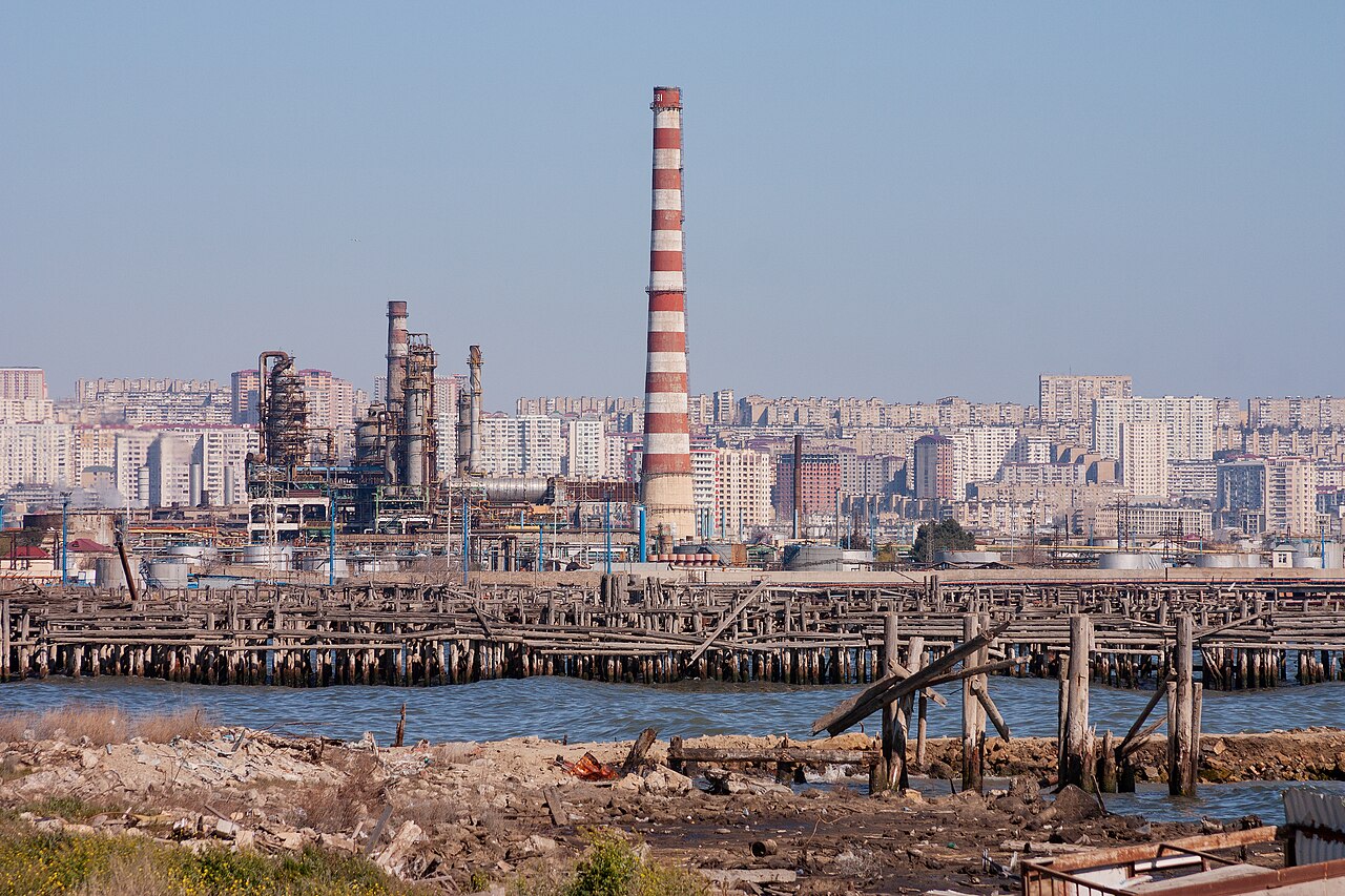
Five times the size of Lake Superior, the Caspian sustains a broad diversity of animal life and has long been celebrated for its caviar trade and oil extraction. Yet the very industries that make it economically significant have also damaged its fragile ecosystem. Oil-sector pollution and the construction of dams on rivers feeding the basin have degraded water quality and disrupted habitats. The sea's salinity averages about 1.2 percent, roughly one-third of typical ocean water, with the northern reaches fed by the Volga—Europe's longest river—remaining nearly fresh while the Iranian shore, receiving little catchment flow, is the most saline. The Garabogazköl lagoon to the east, which dried up in the 1980s when inflow was blocked and has since been restored, routinely exceeds oceanic salinity tenfold. Looking ahead, projections indicate that global warming combined with desertification will reduce the sea's depth by 9 to 18 meters over the 21st century, a scenario experts describe as an ecocide.
Five Nations, One Shared Shore
The Caspian's coastline is divided among five modern states: Kazakhstan to the northeast, Russia to the northwest, Azerbaijan to the southwest, Iran to the south, and Turkmenistan to the southeast. The water sits at the crossroads of Europe and Asia—east of the Caucasus, west of Central Asia's broad steppe, south of Southern Russia's fertile plains, and north of Iran's mountainous plateau. Its political borders have shifted with empires: the Soviet Union and Russian Empire once held the northern shore, while the Pahlavi and Safavid dynasties controlled the south, and the Ottoman Empire bordered it to the west. The sea is physically divided into three zones by two tectonic thresholds—the Mangyshlak Threshold separating the Northern and Middle Caspian, and the Apsheron Threshold between the Middle and Southern sections. These structural breaks create horizontal gradients in temperature, salinity, and ecology that mirror the cultural and political diversity of the nations sharing its waters.
Gallery
Frequently Asked Questions
What is the Caspian Sea?
The Caspian Sea is the largest enclosed inland body of water on the planet, straddling the boundary between Europe and Asia. Because it is a closed endorheic basin with no outlet to the ocean, many geographers call it the world's biggest lake, yet it is universally treated as a full-fledged sea.
Which countries share a coastline with the Caspian Sea?
Five nations border the water: Kazakhstan and Russia along the northern shore, Azerbaijan and Turkmenistan on the eastern and southern edges, and Iran along the far south. Its deepest point plunges to roughly 1,025 meters, placing the bottom about 1,023 meters below sea level.
Why is the Caspian Sea economically important?
The basin is world-famous for its caviar harvest and its vast offshore and onshore oil reserves, which have anchored the economies of the surrounding states for generations. These two industries remain the primary drivers of trade and employment along its shores.
What environmental threats does the Caspian Sea face?
Decades of oil extraction and processing have introduced persistent pollutants into the water and surrounding habitats. On top of that, large dams built upstream on rivers that drain into the basin have reduced freshwater inflow, stressing native species and altering the sea's salinity balance.
How does the Caspian Sea differ from a true ocean-connected sea?
Unlike seas that exchange water with the open ocean, the Caspian is a sealed endorheic basin where water leaves only through evaporation. That isolation creates a self-contained ecosystem with its own salinity gradients and endemic species, setting it apart from any oceanic body of water.
More in Rivers And Seas Of The World 1-24
Related in Rivers And Seas Of The World
Links follow this subject's own source article.
Spotted an error? Know more?
This is a living reference — every entry is fact-audited, and reader corrections feed straight into our audit queue. Suggest an edit · See this site's audit record